There is a rich pool of videos which we can tap on for teaching and learning:
Youtube
Teachertube
Vimeo
CNA Video
RazorTV
News from HD5 on youtube
I have embedded quite a number of videos from CNA and RazorTV on my blogs to update the students in the latest development in Geographical issues

Nov 15, 2012
Nov 10, 2012
ICT sharing by English teacher
So happy that my colleague teaching English language started her blog to share the use of ICT - http://beworldlywise.blogspot.sg/
Nov 9, 2012
Powerpoint Games
Discover a site which uses powerpoints to generate games for lessons - http://people.uncw.edu/ertzbergerj/ppt_games.html
One example will be what is behind the box which you can download from the link above.
Download What's Behind the Box 8
Download What's Behind the Box 16
One example will be what is behind the box which you can download from the link above.
Download What's Behind the Box 8
Download What's Behind the Box 16
Instructions:
1. Teacher or Trainer places unique background images (just insert a picture and right click on the picture and 'send to back' on the pop up menu) behind four to five slides.
To Play:
1. Teacher or Trainer places unique background images (just insert a picture and right click on the picture and 'send to back' on the pop up menu) behind four to five slides.
To Play:
1. Divide into Teams.
2. Each team is asked a question. If they answer correctly, the
teacher clicks the Remove box button one time.
3. This removes one box from the board, if the team can guess
what the picture is correctly, they win. If they cannot guess it correctly the
game continues.
4. Once a team has correctly identified the picture, teacher
clicks the next slide button in the upper right to go to the next board.
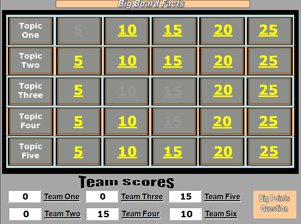
I like the big board game too - just replace the topics and the questions.
The teams get to choose the topics and the questions.
If they get it right the points are recorded at the bottom of the board.
Download Big Board Facts
Download Big Board Facts with Answers Slide

I like the big board game too - just replace the topics and the questions.
The teams get to choose the topics and the questions.
If they get it right the points are recorded at the bottom of the board.
Download Big Board Facts
Download Big Board Facts with Answers Slide
Oct 4, 2012
ICT mentor sharing 18 Oct 2012
Peihwa Sec ICT mentor sharing now -http://linoit.com/users/fahmie/canvases/ICT%20Mentor%20Programme-Session%204
Handson - http://ruslinys.wix.com/question2
I tried it out the wix myself- quite a easy-to-use website builder.
http://lilylee.wix.com/mrslilylee
http://lilylee.wix.com/sec2geog
Was also encouraged to email fahmie_abdat@moe.edu.sg for new lesson plan based on any ICT tools
I have tried out Weebly - another website builder last year:
http://singaporegeography.weebly.com/index.html
http://singaporesocialstudies.weebly.com/
Comparing Wix with weebly from http://getawebsitebuilder.com/comparison/wix-vs-weebly
My comment: Though Wix looks impressive with the flash interface and free templates, I am quite hesitant to use it long term as the disk space for the free version is only 500MB.
I remembered when I first started my website in 2002 - I used Yahoo page builder. I had to migrate some to blogger after they decided to impose a charge somewhere in 2006...it was a nightmare as I had over 20 sites and I lost some data as I could not transfer the data for some. However WIX will be a useful website builder which the students can use to present and reflect on their findings. It is user friendly and the graphics is visually appealing.
Google site is another useful website builder which you might want to try.
I am still more comfortable with blogspot.com - faster updates!
ICT mentor sharing 20 Sept 2012
Evaluating the Effectiveness of the WFP through Food Force Game
Sharing by Pei Hwa Secondary in the latest ICT mentor sharing:
First Task: Students to download and play Food Force game .
download game - http://www.download-free-games.com/freeware_games/food_force.htm
or play on facebook http://apps.facebook.com/foodforce/
Students will download and play Food Force game at home or they can play it on facebook).
The students are required to complete all 6 missions in which they will realise the difficulties organisations face when providing food aid to countries. Students will then research for real examples cited in the WFP website that substantiate their findings from the Food Force Game and thereafter use the examples in to help answer the evaluative question on WFP.
More details available on edumall http://ictconnection.edumall.sg/cos/o.x?ptid=711&c=/ictconnection/ictlib&func=view&rid=968 - login needed.
Glogsters for Sharing
Sep 18, 2012
N3 Cluster ICT Symposium Sharing on Prezi
I shared with some teachers from the N3 cluster during the ICT symposium on how I used Prezi, Linoit and Blog for my Sec 2 class on tourism today.
You can refer to my earlier post on how to use Prezi -http://ezitnew.blogspot.sg/2012/09/prezi.html
For Linoit you can refer to my post on http://ezitnew.blogspot.sg/2011/09/creating-sticky-note-and-embed-in-your.html
For Blog you can refer to my post on http://ezitnew.blogspot.sg/search?q=blog
My students' works are on http://2etourism.blogspot.sg
The powerpoint which I used today:
Sep 13, 2012


Collaborative learning using Titan Pad
Another online tool for collaborative learning. Registration is free on http://titanpad.com/ and you can create word pad which the students can collaborate online real time. One of my colleagues, Mrs Lee Wei Sin, teaching English actually assigned pairs to work on writing a speech. You can samples of her students' works here: http://beworldlywise.blogspot.sg/2012/09/titanpad-collaborative-writing-tool.html
The changes made by members can be tracked and shown in different colours. The teacher create the writing pad and set a password. Then she shared the link and password to the respective groups.


Sharing some of the students' works that was done by my colleague on constructing a speech. It really get the students to reflect on their work and improve on them. Teacher's comment is in Green here.


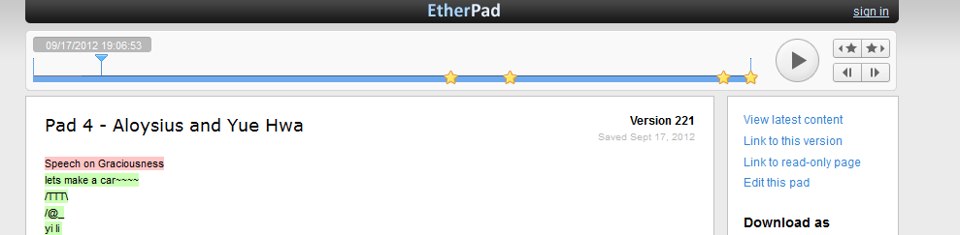
Another sample of the work - constructing the conclusion.

Jun 23, 2012
Apps from Google Play (Android Market) for Geography
I am really amazed at how technology has advanced and the no. of apps for smart phone or tablets I could use in my Geography lessons. I used to have to bring quite a no. of instruments for fieldwork e.g. ranging poles, clinometer and compass.
In the latest field inquiry course which I attended, I downloaded the clinometer, stop watch and smart compass to my handphone and tablet. By using the clinometer, we could actually measure the gradient of the beach easily. At every 1m interval, we measured the gradient by placing the phone/tablet on the beach and recorded the gradient. We were able to plot the beach profile from all the data collected. We realised that the gradient was steeper on one side of the beach behind the breakwater and suspected there is a drift of sediments towards the east - we had used compass application to determine our location.
I realised that if we want to use the ranging poles and clinometer to measure angle - the smart protractor would be useful as well.
We also decided to check on the wave energy and determine whether the wave energy is high and the need to construct the breakwater to reduce the energy before it hits the coast. Using the stopwatch and timer we time the no. of waves per min. True enough the count was 20 per min which indicated high wave energy. Another useful application would be the smart measure which we could measure the height of the breakwaters or the distance between them. It seemed that the breakwaters over our stretch of coast are slightly higher and nearer to each other.


Sketching for geographical inquiry - you can use the app Sketchart or protrait sketch to turn your image into a sketch instantly!


Another application which you must have is Get Altitude - it not only shows you the Altitude but also the longitude and latitude - sometimes I feel that the location is even more accurate compared to Google Map.


A similar sharing by another teacher in UK but more of iphone in Geography fieldwork -https://docs.google.com/present/view?id=dhntzwtf_58cpcsgjg8
In the latest field inquiry course which I attended, I downloaded the clinometer, stop watch and smart compass to my handphone and tablet. By using the clinometer, we could actually measure the gradient of the beach easily. At every 1m interval, we measured the gradient by placing the phone/tablet on the beach and recorded the gradient. We were able to plot the beach profile from all the data collected. We realised that the gradient was steeper on one side of the beach behind the breakwater and suspected there is a drift of sediments towards the east - we had used compass application to determine our location.
I realised that if we want to use the ranging poles and clinometer to measure angle - the smart protractor would be useful as well.
We also decided to check on the wave energy and determine whether the wave energy is high and the need to construct the breakwater to reduce the energy before it hits the coast. Using the stopwatch and timer we time the no. of waves per min. True enough the count was 20 per min which indicated high wave energy. Another useful application would be the smart measure which we could measure the height of the breakwaters or the distance between them. It seemed that the breakwaters over our stretch of coast are slightly higher and nearer to each other.


Sketching for geographical inquiry - you can use the app Sketchart or protrait sketch to turn your image into a sketch instantly!

Sketch guru is also very useful in creating a field sketch instantly. 

Of course, many people would have found Google Map useful. Whenever I am at a new place, I will use it to help me to navigate around. You must also install Street View on Google Map. With Google Maps Street View, you can explore the world at street level. Just open Google Maps, search for a place or long-press the map, and tap the Street View option.


You can measure the area and distance on Google Map using Area Calculator which is relatively easy to use as shown below:

Use Google Earth to fly around the planet with the swipe of a finger. Search by voice for cities, places, and businesses. Browse layers including roads, borders, places, photos and more. For tablet users (Android 3.0 or newer), you can get easy access to search, reset-to-north, my location, and layers. Also, on tablets and select phones, you can now explore the same photo-realistic 3D buildings that have previously only been accessible with the desktop version of Google Earth.


I also like Earth Zoom Pro - you can zoom from Space to Ground level to famous places such as Machu Picchu, Petra, The Forbidden City, Pyramids, Taj Mahal More

Google Goggles is another useful application which could help me to identify an object.

The following are some useful apps on weather studies -
The weather channel allows one to track the weather conditions and forecast around the world and you can choose the layer as well as the type of map. There are also videos related to videos as well.

Weatherlah keeps all Singaporeans up to date about the latest weather forecast with a clean and easy to use interface. The app can notify you of incoming rain, rise in PSI levels and even extreme weather warnings.You can also click on drain in the map mode to see whether the drains are flooded or low in water level around Singapore.

Wind speed is a wind convertor which allows you to convert between many various wind speed measurement scales e.g. Beaufort scales to km per hour .Click on the i icon and you can find out more what the scale represent e.g. on Beaufort scale 5 leaves begin to sway and on beaufort scale 10 trees are broken off or uprooted.
T-counter is very useful in counting traffic - you can have 4 counters at the same time e.g. one for car, one for bus, one for taxi and one for others! just touch the + button to add on. Good for field inquiry in Human Geography for human traffic as well.

Another tool useful for human geog is tape-a-talk which is useful for interviews. The recording is saved in wav file and can be played back on computers. Of course you could also use the camera function on your phone but some people might not want to be captured on video.
You can create a dropbox account on your computer as well as download the dropbox app onto your handphone and the files can all be uploaded and share.
I also like Kingoffice which allows you to view as well as edit office documents - words, excel, powerpoint.
Another amazing application is 3D Earthquake. Like what I have told my students - earthquakes occur everyday - just that the magnitude might be small and not reported in the news. It shows the plate tectonic - that the plates are moving and you can change the setting to show the plate boundaries and how these earthquakes coincides with the plate boundaries.

Simearthquake is another app which is very good to illustrate how magnitude affects the extent of damage from earthquake.
Volcano report is also an interesting app to know the latest volcanic eruptions in the world. Explore volcanoes which have been active in the last week on an interactive map. For every single volcano you get detailed information about the ongoing activity and their eruptions.

Of course as a geography teacher, the app World Map and National Geographic Explorer are also indispensable. However I could not add National Geographic Explorer to my Motorola Xoom - only on my husband's Lenovo K1

Learn more about Geography Natural and Man-made Features - Natural features part 1 and part 2, Man-made features part 1 and part 2. There are also many other apps on Geography games and quiz. And of course the best part about all these apps are that they are free!
A similar sharing by another teacher in UK but more of iphone in Geography fieldwork -https://docs.google.com/present/view?id=dhntzwtf_58cpcsgjg8
Jun 4, 2012
Using Google Earth for Geographical Enquiry
Attended the workshop by Paul Cornish on the use of Google Earth for Geographical Inquiry during the Humanities Educators' Conference 2012. Would definitely try this out - maybe for Kalimantan but need to find the resources first. Definitely good for self-directed and collaborative learning.
You can find out more from http://www.gecpd.com/p/ga-conference-2012.html
Rosewood Enquiry


This is the Rosewood enquiry by Paul Cornish - make sure you have Google Earth installed and you can open the following files- /Rosewood Enquiry.kmz
I tried this out myself and did one on Kalimantan -Kalimantan Deforestation.kmz
I have listed below how I created the Kalimantan file:


One example shared by a UK teacher on Mt St Helen - click on the link below to download the kmz file-http://www.4shared.com/file/1uTWGnUq/Mt_St_Helens_Case_Study.html%20
You can find out more from http://www.gecpd.com/p/ga-conference-2012.html
Rosewood Enquiry
Multimedia Geography through Google Earth from Paul Cornish
Embedding
Google Earth is constantly connected to the internet and constantly
‘streams’ satellite images. This gives the opportunity to create a ‘window’ in
a place mark, and view photos, video and listen to audio hosted on other sites
through the use of simple HTML code.
Embedding Photos

From Flickr.com
(photo sharing website):
- In GE, create a place mark
- Find the photo you want to use and click ‘Share’
- Copy the HTML code
- Paste into the place mark
- Name the place mark accordingly and add text
- Snapshot view
Embedding Video

From Youtube or
Vimeo (video sharing websites):
- In GE, create a place mark
- Find the video you want to use and click ‘Share’ and then ‘embed’
- Copy the HTML code
- Paste into the place mark
- Name the place mark accordingly and add text.
- Choose angle and snapshot view
Embedding Audio

From
Audioboo.fm (audio sharing website):
- Use the Audioboo website to search for audio or create your own using the iPhone app.
- In GE, create a place mark
- Find the audio and click ‘embed’
- Click ‘more options’ and choose ‘if all else fails’
- Copy the HTML code
- Paste into the place mark
- Name the place mark accordingly and add text
- Choose angle and snapshot view
Snapshot View

A snapshot view
enables Google Earth to zoom into a pre-chosen angle to show video, photo or
audio files
1. Choose the angle and altitude
for your place mark
2. Either right click on the file in the ‘places menu’ or right click
on the
place mark
3. Click ‘snapshot view’
Collaborative Learning using Geographical inquiry:
This is the Rosewood enquiry by Paul Cornish - make sure you have Google Earth installed and you can open the following files- /Rosewood Enquiry.kmz
I tried this out myself and did one on Kalimantan -Kalimantan Deforestation.kmz
I have listed below how I created the Kalimantan file:
Open up Google Earth ( you can download it free from http://www.google.com/earth/index.html)

Right click on My Place and a pop up window will appear – click on
“Add” followed by “ folder”

Click on the icon placemark.

A pop-up box will appear and you can copy the html code from
your source – e.g. youtube as shown below. You can drag the placemark to the location or
just type in the latitude and longitude.


Right click on your folder and then click “ save place as..”
– it will be saved as a kmz file.
One example shared by a UK teacher on Mt St Helen - click on the link below to download the kmz file-http://www.4shared.com/file/1uTWGnUq/Mt_St_Helens_Case_Study.html%20
Subscribe to:
Posts (Atom)