May 28, 2020

Timed quiz in Google classroom

Just learned you can create a timed quiz in Google Classroom by using Google Forms, the Forms add-on FormLimiter, and the scheduling function in Google Classroom.


Step-by-step directions:
1. Create a new quiz assignment in Classwork in Google Classroom.
2. Create your quiz in the Google Form that was created by step 1 above.
3. Install the FormLimiter add-on for Google Forms.
4. Enable a date and time limit in the FormLimiter add-on.
5. Use the scheduling tool in Google Classroom to make your quiz live at a specific time.

Great for assessment!

May 15, 2020

PowerPoint to make sticker

Awesome sharing by Ilyana Anwar.

https://m.facebook.com/groups/214056932415492?view=permalink&id=855356961618816

She has used PowerPoint to draw these very cute cartoons and make them into stickers!

http://sticker.ly/s/ZQAY02

May 11, 2020

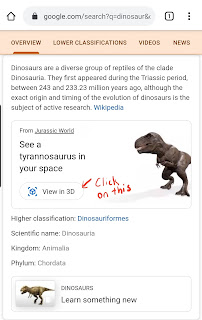
AR using Google search

Totally cool option on Google mobile search!
Do a Google search and click on "View in 3D".
Then select "view in your space".
Boom! An Augmented Reality of your search appears! Use this on my hand phone but I do see a lot of possibilities using this. Learned this through the sharing of Brian Calligy in FB Teachers using Google suite.
You can get the students to create a story or narration on an animal by bringing the AR animal into their space.


Animal cell. There is a recording function available too in the AR mode.


Bacteria in AR!


Gotten a VR parrot, fish and dog to star in the video with my conure in AR. The sound is available too!


Check out the list of human body experience and 3D models of cells here.
I think it will be amazing for bio classes
Updated list 


Using Google Search 3D view in my space to bring a giraffe to celebrate Christmas using AR!

Using Google search AR, I had fun bringing the dinosaurs to Universal Studio Singapore as well!


Had great fun using the AR to create dinosaurs and animals in USS.
 
Tips: Press the circle longer for video after you see the dinosaur in 3D view in your space. Rotate it to landscape when recording and in gallery rotate it again


Refer to the link below for updated list of AR animals and characters.

So, what AR animals can you view on Google Search? These include:

New character is grogu from The Mandalorian as well as the child from star trek

Launched 28 July 2020, there are 23 insects for you to find in Google Search. You can pinch and zoom-in on the 3D model — which includes faux lighting conditions or leverage augmented reality to see them in your environment with the “View in your space” button.

rhinoceros beetle, Hercules beetle, Atlas beetle, stag beetle, giant stag, Miyama stag beetle, shining ball scarab beetle, jewel beetle, ladybug, firefly, Rosalia batesi, swallowtail butterfly, morpho butterfly, atlas moth, mantis, grasshopper, dragonfly, hornet, robust cicada, brown cicada, periodical cicada, Walker’s cicada, and evening cicada.


May 7, 2020

Interactive Google slides

Chanced upon this Google slides tutorial.

Love the following:
1. Picking the colour and duplicating it from a chrome extension Colorzilla
https://chrome.google.com/webstore/detail/colorzilla/bhlhnicpbhignbdhedgjhgdocnmhomnp?hl=en

2. Remove the background of a picture
https://www.remove.bg/

3. A resource of GIF images
https://giphy.com/

4. Bitmoji
https://chrome.google.com/webstore/detail/bitmoji/bfgdeiadkckfbkeigkoncpdieiiefpig?hl=en

Google slip in slide

Thanks to DL Fedder for allowing me to share the awesome post below.
Slip-in-Slide allows you to make slide shows your go-to tool for presenting information to students in Google Classroom because you can "SLIP" a slide into presentations AFTER you've made a copy for each student! What a great way to share weekly assignments, daily journal posts, or even for those times when you forget to add something!
The talk and comment extension sounds amazing.
Her sharing @
https://sites.google.com/view/dlfedder


May 2, 2020

Virtual learning journey

The video below is a 360 video of the Chinatown LJ for Tourism GI 2020. You can also move horizontally through the 360 video by dragging your finger across the screen if you are using your handphone. You may also pause the video and swipe on the screen for the 360 view. Though you cannot experience the smell, the sight and sound would be an amazing VR experience.


You can watch it in VR if you open up the video in YouTube. Experience the virtual reality with VR glasses. Virtual Tourism GI


More of 2020 tourism GI here 


Did a virtual Coastal GI in UK too using Google Earth. An overseas virtual learning journey!
Gotten the students to make observation using street view as well using the ruler in Google Earth to do measurements. I actually gotten the students to 'fly' back to Singapore to compare the size of the one we have at ECP with that in UK. Gotten them to think why are the breakwaters wider in UK.
Google Earth Kmz file and worksheet I have created can be downloaded from my Google site@

Sec 1 virtual Water GI using Google Earth. Let's fly over to Lorong Halus!
Students learn more about the history of the place.
https://sites.google.com/a/moe.edu.sg/sec-1-geog/geographical-investigation/5-lorong-halus-wetlands

They can also see how the place was in the past using the time slider with Google Earth.
https://sites.google.com/a/moe.edu.sg/sec-1-geog/google-earth

Then visit the various location via the street view on Google Earth.


For sec 2 we actually gotten the students to annotate a picture of their neighbourhood to show why it is a unique place for them. Some were not able to be there so they made use of Google Earth and screenshot the street view. They drag the pegman to the spot where there is blue line to see the area in street view.


Updated  5 June- Alex shared on the following 360 video of the Toa Payoh Neighbourhood.


This also reminded me of the sharing on using VR for Housing GI shared by Hua Yi sec
http://geogshare.blogspot.com/2019/11/vr-in-geography.html

Updated Aug 2020: Use of VR by Ms Yong from Teck Whye Sec
https://www.schoolbag.edu.sg/story/first-person-real-issues-virtual-classroom

Do also look at my earlier post on the use of MOE arcgis resources.
http://geogshare.blogspot.com/2020/03/arcgis-resources.html

I have always love Google Earth - My earlier posts on the use of Google Earth:
http://ezitnew.blogspot.com/search/label/Google%20Earth

The use of Google Earth definitely encourage real world exploration. It enables the students to overcome the constraints of space and time, bringing the world into the classroom. Google Earth allows students to locate and explore different parts of the world and the time slider allow one to compare the before-and-after images of an area.   This can definitely help to spark curiosity about the causes and impacts of change as what I have mentioned earlier about the Sec 1's study of Lorong Halus.  

In instances where the location of a study is difficult to reach, teachers can take students on virtual tours. Virtual tours may be in the form of the drag and drop Pegman icon on Google Street View's 3D view. The students could take a virtual trip to see why Machu Picchu in Peru attracts the tourists by moving around the ruins left by the Inca civilisation as well as experience the amazing view from the mountain top. 

Students can zoom, pan, and rotate the orientations of their screen in Google Earth to help them understand geographical space, place, and scale. As mentioned above, the students can use the search and zoom functions on Google Earth to explore Lorong Halus. The ability to observe features in Google Earth by manipulating the map scale actively and easily allows students to have a better sense of how the waterway, e.g Punggol waterway, are connected at a locale and even factors that may affect the water quality in the waterway. 

My Sec 3 students have also enjoyed measuring the breakwater in UK and compare that to the one at ECP using the ruler function in Google Earth. In doing so they could better understand the geographical concept of scale as well as making observations on the reasons for the difference in sizes.  Spatial analysis could be carried out and exploration of the real world without them actually being there with virtual field trips!

I have created a Virtual Coastal GI using Google Earth and simulations in school.
You can read more here: