Jun 30, 2017

N3 ICT symposium 2017 Google and Apple

Excited to learn more ICT tools and classroom apps which we can use.

Google online tools
Thanks to Yijie for his wonderful sharing on online assessment tools. 
You can see more of his sharing on his blog - https://borderlesslearningblog.wordpress.com/

Had been using Quizlet and was not aware of the live version which allows for collaborative learning.
You can learn more of Quizlet Live here https://quizlet.com/en-gb/features/live
My earlier post on the use of Quizlet: http://ezitnew.blogspot.sg/2014/04/quizlet.html

Tried out the Quizlet.live during the concurrent session:
https://quizlet.com/live
Through this, the students will learn the rule of the game on their own and collaborate to win the game by matching the correct answer to the question. As they are assigned to a team by the game, they will have to work with classmates whom they might not have work with. It was kind of chaotic when we were told to look for our group assigned. And as we were not sure how it was played, many of us had to start all over again.
Hint: the answer is only available to one member of the group and if it is matched incorrectly, the group has to start all over again.

Edpuzzle.com which you can produce interactive video in which questions can be inserted at intervals to assess the viewer's understanding. I just hope that it's as useful as zaption which had been shut down. Was really disappointed when they shut down zaption and those which I had embedded in Google sites could no longer be used. Hope this will stay.

Will be trying another similar tool which I saw online. Rich lesson resources shared on http://ed.ted.com/ and you can also create your own! Like the fact that you can add in questions to check for understanding (Think) as well as able to post information and links for them to explore further (Dig deeper). It also provide a platform for discussion (Discuss). 


Learned this from another member of the  SG Learning Designer circle - https://www.playposit.com/

Wow so much to explore - will compare the 3 above!


This one on animated tsunami is so good - http://ed.ted.com/lessons/how-tsunamis-work-alex-gendler#review 

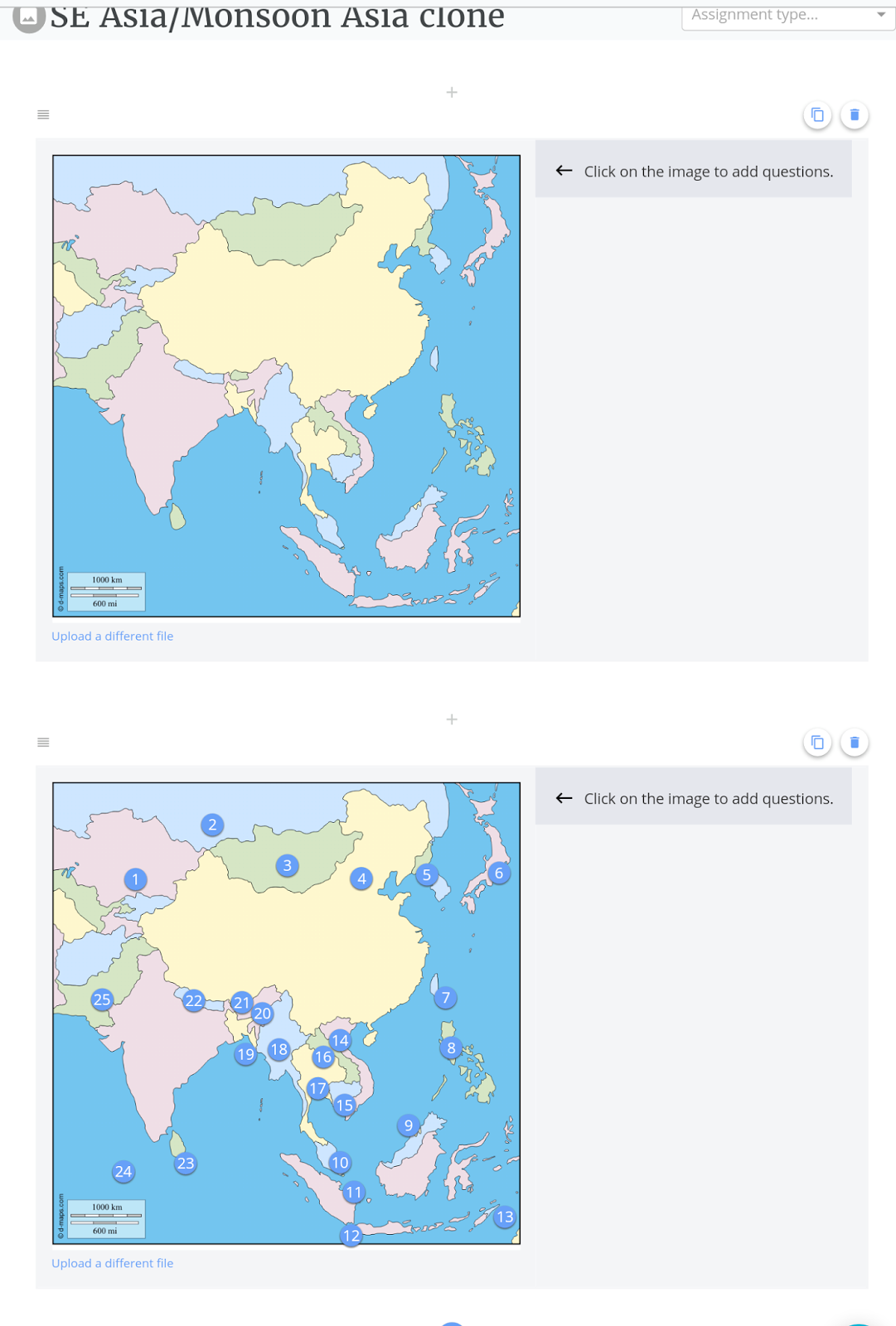
Goformative.com seems good with a library of ready available assessment such as one to label countries in Asia. It can be easily cloned and new questions added. Will feedback more when I try it out with my classes.


A lot more to explore @ http://flippity.net which seems to be similar to  http://www.classtools.net which I have been using.


Have yet to explore pear deck and quizzi. I had posted on the use of kahoot which I shared in the symposium 2 years ago 

http://ezitnew.blogspot.sg/search/label/kahoot?m=1

Comparison of the tools:


Apple classroom apps

With Apple Classroom, you can easily launch the same app on every student device at the same time, or launch a different app for each group of students. Love the control Apple classroom has but need to check out the hardware such as Apple TV and the wifi router etc as well.

I love the control the teacher has over the class as I could launch an app to all students and get them all to work on it e.g. notes.

To ensure that all of them are on task, I can lock the app for the duration which I want the students to work on e.g. notes

Using the connection with Apple TV connected to the projector, the teacher can disconnect and allow selected sudent to share his or her work via airplay. An improvement will be addition of screen code so that only the selected student has access to the projection. I can also lock their iPads and get them to focus on the whiteboard or other tasks not on iPad. The teacher can also mute students iPad if it become too noisy.

However the app only work  with version 10.3 and above. The students will need to switch on the wifi and bluetooth on their ipads. With the apple TV connected to projector, the teacher can move around with the ipad and monitor the class with the ipad.




May 19, 2017

Innovative ideas for classroom

Love the ones on QR code. #3 (How QR code is used in Maths homework linking work given to a video which helps the student in the assignment), #39 (QR code to help identify plant or trees) .
I have posted on the use of QR code and I must say the use of it had expanded to getting audience scanning it to to link it to surveys.Click on the link below for my post on the use of QR code
http://ezitnew.blogspot.sg/search/label/QR%20codes?m=1


Whether you're in middle school, high school, university, or anything in between, it has never been a better time to be a student. Schools around the globe are…
BOREDPANDA.COM
Innovative ideas for the classroom:
http://www.boredpanda.com/creative-school-education-ideas-innovations/?utm_source=facebook&utm_medium=link&utm_campaign=BPFacebook

Use of Powerpoints for Quiz and Games

I have created a very simple template with countdown timer (animated gif) for 1 min, 2 min or 3 min. You can duplicate the slide for the time frame you would like each question to run for your quiz. https://drive.google.com/file/d/0B9UR3aEsvgerckdqODZYSmN3RGM/view?usp=sharing

The following is a very useful sites which provide some powerpoints templates to generate games/qui for lessons - http://people.uncw.edu/ertzbergerj/ppt_games.html

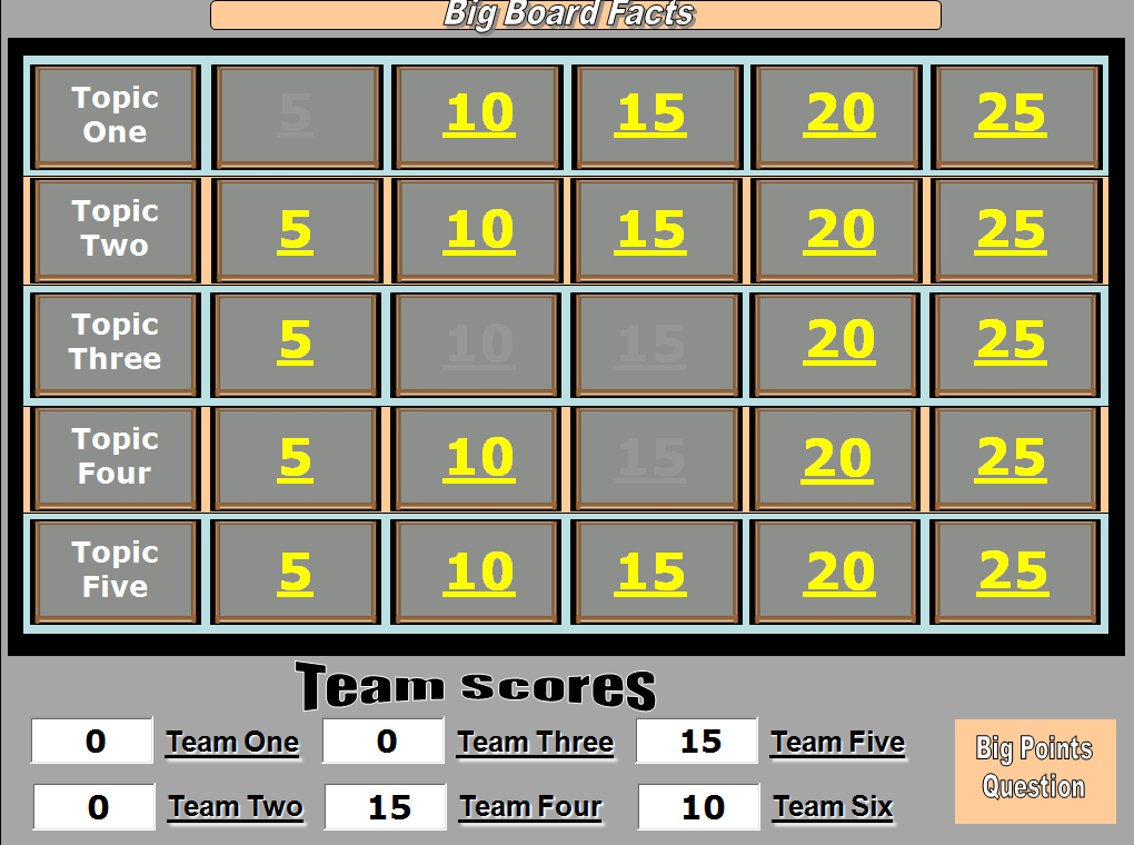
I like the Big board game  - just replace the topics and the questions. 
The teams get to choose the topics and the questions.
If they get it right the points are recorded at the bottom of the board. 
Download Big Board Facts
Download Big Board Facts with Answers Slide


Louie guess is very much like the pyramid game show. In this game students will describe words or phrases that Louie is thinking about in an effort to get other students to say those words or phrases. But they have to be fast cos there is time limit to read his mind! 
Download Guess Louie


Another good one will be what is behind the box which you can download from the link below!:
Download What's Behind the Box 8
Download What's Behind the Box 16 


Instructions:
1. Teacher or Trainer places unique background images (just insert a picture and right click on the picture and 'send to back' on the pop up menu) behind four to five slides.

To Play:
1.      Divide into Teams.
2.      Each team is asked a question. If they answer correctly, the teacher clicks the Remove box button one time.
3.       This removes one box from the board, if the team can guess what the picture is correctly, they win. If they cannot guess it correctly the game continues.
4.      Once a team has correctly identified the picture, teacher clicks the next slide button in the upper right to go to the next board.

Apr 24, 2017

Google Earth

Just realised that I have not posted this sharing on Google Earth in inquiry-based learning which I shared with my colleagues June and Kelly @ the Humanities network on 7 April 2017 at Fajar Sec. The slides which we used for the sharing.


Making use of what I had learned from Paul Cornish in the Humanities Conference. You can also click on the link below to see how to create kmz files for geographical inquiry:
http://ezitnew.blogspot.sg/2012/06/using-google-earth-for-geographical.html

You can download Google Earth free here: http://www.google.com/earth/download/ge/agree.html


This is how the screen will look when you open up Google Earth app or plugin.


Perform searches from the search box at the top left side of the program. Let's visit Machu Picchu! 
This was very useful when I get the students to take a virtual trip there and explore the area as a place with rich heritage... some were debating that it is a place with scenic beauty as it is high up in the mountain! This virtual trip get them to relate better to the issues mentioned in the textbook such as erosion of the footpath etc. They learn better through authentic learning.

You can type a place name, zipcode or postcode, a town/city name, an airport or you can even try to type in a latitude-longitude location (in decimal format). Once you press the  Enter key, you'll be "flown" to that destination.  You can take a virtual holiday!
You can also drag the little yellow man icon to the map and you will get to see street view. I do this before I visit a place so that I can navigate the place easily when I am there!


Use the zoom out and zoom in options from the buttons on the right hand side of the screen.
Turn the wheel in the top right corner to spin the item to a better understood angle. 


Click on Exit Street view to go back to the map.

Look for the date the picture was taken from the bottom left hand corner of the screen.

My colleague, June, shared on how she use Google Earth to prepare the students for their GI in Chinatown. Indeed the tool is useful for them to take a virtual visit before the actual field investigation so that they will not be lost. The students can also be shown how to do the landuse survey, marking the main landuse on both sides of the streets.


Use of Google Earth for Physical Geography https://sites.google.com/a/moe.edu.sg/sec3geog/google-earth

I have attached some of the kmz files below which you can explore. There are also many kmz or kml files which you can use with Google Earth online.

2 of the kmz files attached below were created by me - one on map reading which is the coastal area south of UK. The map was from one of the N level papers. 


The other file is the Earth Tectonic plates. I have place marked the features or the plate boundaries you see the actual locations on Google Earth. 


Earthquake around the world kmz - WWeqANSS.kml  attached - Have you wondered where and when did earthquakes of magnitude 8 or 9 occurred? Open up the file and find out!


Open the earthquake focus file attached to see whether there is a relationship between the depth of focus and the plate boundaries.


Use the 4degrees file to investigate the areas where there are higher increase in temperatures.

Open up the Hurricane Katrina file to see the historical images on how the hurricane formed and moved over New Orleans. Scroll through the dates to see all the satellite images from different days of the year. 
Drag the location of the toggle slider switch in the top left corner to a different date and see what the area was like. e.g. you can see what New Orleans was like after Hurricane Katrina, or one of the many famous historical times that date back to 1990! 


Google Earth for Sec 2 https://sites.google.com/a/moe.edu.sg/sec-2-geog/using-google-earth presented by my colleague, Kelly.

You can also drag the yellow man button on the left to any of the blue line and you can see the street view.


This is one of the street view of Tokyo. Look at the high rise buildings and more developed infrastructure e.g. flyover, wider roads congested with cars etc.


The second file is on the Favela in Brazil (slum).  

Open the file with Google Earth. You will see the Favela area marked by a yellow line. 
To see the street view, drag the yellow man icon on the right to any point on the blue line.


You will able to virtually walk down the street by clicking on the road. Click on Exit Street View on top right hand corner to go back to the aerial view of the Favela zone in Brazil.

Look at the living conditions of the people in the favela by taking a virtual walk in the area using street view.

Look for the date the picture was taken from the bottom corner of the screen.
Scroll through the dates to see all the satellite images from different days of the year. 
Zoom to a place on the map where the satellite image has a date, click the "View" menu from the menu bar and click the "Historical Imagery" button to enable the feature. 
Drag the location of the toggle slider switch in the top left corner to a different date and see what the area was like. e.g. you can see how the Serangoon River mouth was like before the dam was built in 2010 in 2005, 2008 and 2010.


Click on the attached file below 'Forest' and then click on the pie charts in the various countries and find out which countries experience high rate of deforestation.

How much forest cover has Singapore lost?


Amazing effort by a teacher on enhancing the use of Google Earth through coding and design of app - something which I have yet to learn ( I just know how to use html with help of designer code in dreamweaver) https://www.gearthblog.com/blog/archives/2011/12/using_google_earth_in_the_classroom.html
The app online he created: http://www.geteach.com/ Love how you can analyse the maps side by side e.g. the population density versus the topography  etc

The Google Earth pages with files attached on my Google Sites:

Sec 1 

Sec 2 

Sec 3 

Sec 4 


Visible learners and engaging pedagogy

Love the sharing by my colleagues Elisabeth and Wen Ee today.

In fact there is a need for active and collaborative instruction coupled with various means to encourage student engagement which will invariably lead to better learning outcome.

The use of technology can help to engage the students and becoming visible learners. They shared with us the following links which contain very useful apps or website for educators.

http://www.educatorstechnology.com/2017/01/70-educational-ipad-apps-for-teachers.html

The Ultimate EdTech Chart for Teachers and Educators www.educatorstechnology.com

Another good resource shared by Wen Ee is freetech for teacher
A bit of "magic" using Aurasma which would definitely excite the students as they can use the app to see the picture comes alive in the form of a video. 

Engaging students using the app aurasma
I have learned about this 2 years ago and had wanted to try but have not done so. Decided to try a simple one using a photo of the tuned mass damper in 101 building to trigger an interesting video clip from a Taiwan news report.


You can try to use Aurasma to scan the following picture:

And it will come alive in the form of a video  (https://www.youtube.com/watch?v=VJDpDkDUYOE) on the screen!

To create an aura:
Sign up for an account @ https://www.aurasma.com/


Aurasma app can be downloaded 

Just activate the app and you can scan the trigger picture. Students will be amazed how the video will suddenly come alive in VR! Try it out today!


Extracted from my earlier post on Aurasma below:


An interesting app shared during the ICT symposium 2015 - Aurasma
It can be downloaded from App Store for IOS and Play store for Androids (however my Samsung Note 4 is not compatible and cannot download it. It works on my Samsung Galaxy Pro)
The app offers a lot of potential in creating virtual learning. 


Aurasma allows users to create or view augmented reality experiences. The user open up the app and capture the photo with the camera. The image will transform into a video, animation, another image or bring you to a website with more information. 
To create their own Auras, students or teachers choose an overlay and a trigger. An overlay is a video, image, an animation or a website link that will appear when someone finds the trigger object or photo. 
Tutorial on creating a sequenced aura using the aurasma studio https://studio.aurasma.com/login
https://youtu.be/CaczBAfdRns - so cool being able to create a scavenger hunt with photos. User just scan the photo and could see a video or even a url link providing more information.

Use of Aurasma in teaching:

https://youtu.be/uHIxYpBW7sc?list=PLYk2ySKukLs6Fih_6xze0EYRyGJguDYCF

Use of Aurasma in learning nature:

https://youtu.be/WRS_nZOOMyY?list=PLYk2ySKukLs6Fih_6xze0EYRyGJguDYCF